The Himalaya Range or Himalaya Mountains ( /ˌhɪməˈleɪ.ə/ or /hɪˈmɑːləjə/;[1][2]Sanskrit: Devanagari: हिमालय, literally "abode of snow"), usually called the Himalayas orHimalaya for short, is a mountain range immediately at the north of the Indian subcontinent. By extension, it is also the name of a massive mountain system that includes theKarakoram, the Hindu Kush, and other, lesser, ranges that extend out from the Pamir Knot.
Together, the Himalayan mountain system is the world's highest, and home to the world's highest peaks, the Eight-thousanders, which include Mount Everest and K2. To comprehend the enormous scale of this mountain range, consider that Aconcagua, in the Andes, at 6,962 metres (22,841 ft) is the highest peak outside Asia, whereas the Himalayan system includesover 100 mountains exceeding 7,200 m (23,600 ft).[3] However the Alleghenian mountains, formed during the formation of Pangaea, likely rivalled or exceeded the Himalayas in height.[4]


The main Himalayan range runs west to east, from the Indus river valley to the Brahmaputra river valley, forming an arc 2,400 km (1,500 mi) long, which varies in width from 400 km (250 mi) in the western Kashmir-Xinjiang region to 150 km (93 mi) in the easternTibet-Arunachal Pradesh region. The range consists of three coextensive sub-ranges, with the northernmost, and highest, known as the Great or Inner Himalayas.
Some of the world's major river systems arise in the Himalayas, and their combined drainage basin is home to some 3 billion people (almost half of Earth's population) in 18 countries. The Himalayas have profoundly shaped the cultures of South Asia; many Himalayan peaks are sacred in Hinduism, Buddhism and Sikhism.
Geologically, the origin of the Himalayas is the impact of the Indian tectonic plate traveling northward at 15 cm per year to impact the Eurasian continent, about 40-50 million years ago. The formation of the Himalayan arc resulted since the lighter rock of the seabeds of that time were easily uplifted into mountains. An often-cited fact used to illustrate this process is that the summit of Mount Everest is made of marine limestone.[5]
Ecology


The flora and fauna of the Himalayas vary with climate, rainfall, altitude, and soils. The climate ranges from tropical at the base of the mountains to permanent ice and snow at the highest elevations. The amount of yearly rainfall increases from west to east along the front of the range. This diversity of climate, altitude, rainfall and soil conditions generates a variety of distinct plant and animal communities. In fact the extrema of high altitude (low atmospheric pressure) and very cold at the most elevated reaches allow extremophile organisms to survive.[6]
Lowland forests
On the Indo-Gangetic plain at the base of the mountains, an alluvial plain drained by the Indus and Ganges-Brahmaputra river systems, vegetation varies from west to east with rainfall. The xeric Northwestern thorn scrub forests occupy the plains of Pakistan and the Indian Punjab. Further east lie the Upper Gangetic plains moist deciduous forests of Uttarakhand and Uttar Pradesh and Lower Gangetic plains moist deciduous forests of Bihar and West Bengal. These are monsoon forests, with drought-deciduous trees that lose their leaves during the dry season. The moister Brahmaputra Valley semi-evergreen forests occupy the plains of Assam.
The Terai belt
Above the alluvial plain lies the Terai strip, a seasonally marshy zone of sand and clay soils. The Terai has higher rainfall than the plains, and the downward-rushing rivers of the Himalaya slow down and spread out in the flatter Terai zone, depositing fertile silt during the monsoon season and receding in the dry season. The Terai has a high water table due to groundwater percolating down from the adjacent zone. The central part of the Terai belt is occupied by the Terai-Duar savanna and grasslands, a mosaic of grasslands, savannas, deciduous and evergreen forests that includes some of the world's tallest grasslands. The grasslands of the Terai belt are home to the Indian rhinoceros(Rhinoceros unicornis).
Bhabhar belt
Above the Terai belt is an upland zone known as the Bhabhar, a zone of porous and rocky soils made up of debris washed down from the higher ranges. The Bhabhar and the lower Shiwalik ranges have a subtropical climate. The Himalayan subtropical pine forests occupy the western end of the subtropical belt, with forests dominated by Chir Pine (Pinus roxburghii). The central part of the range is home to theHimalayan subtropical broadleaf forests, dominated by the sal tree (Shorea robusta). They are at the foot of the Himalayas where the Himalayan streams descend on to the plains.
Shiwalik Hills
Also called Churia or Margalla Hills, Sivalik Hills is an intermittent outermost range of foothills extending across the Himalayan region throughPakistan, India, Nepal and Bhutan. This region consists of many sub-ranges. Summits are generally 600 to 1,200 meters (2,000 to 3,900 ft). Steeper southern slopes form along a fault zone called Himalayan Frontal Thrust (HFT); northern slopes are gentler. Permeable conglomerates and other rocks allow rainwater to percolate downslope into the Bhabhar and Terai, supporting only scrubby forests upslope. The Himalayan subtropical pine and broadleaf forests continue here.
Inner Terai or Dun Valleys
The Inner Terai valleys are open valleys north of Shiwalik Hills or nestled between Shiwalik subranges. Examples include Dehra Dun in India and Chitwan in Nepal. Himalayan subtropical broadleaf forests grow here.
Lesser Himalaya

Also called Mahabharat Range, the Lesser Himalayas is a prominent range 2,000 to 3,000 meters (6,600 to 9,800 ft) high formed along the Main Boundary Thrust fault zone, with a steep southern face and gentler northern slopes. They are nearly continuous except for river gorges, where rivers from to the north gather like candelabra in a handful of places to break through the range.
At these elevations and above the biogeography of the Himalayas is generally divided by the Kali Gandaki Gorge in central Nepal, one of the deepest canyons in the world.
At the middle elevations of the range, the subtropical forests yield to a belt of temperate broadleaf and mixed forests growing between 1,500 and 3,000 meters (4,900 and 9,800 ft), with the western Himalayan broadleaf forests to the west of the Gandaki River, and theeastern Himalayan broadleaf forests to the east. The western broadleaf forests stretch from the Kashmir Valley, across Himachal Pradesh and Uttarakhand, and through western Nepal. The eastern broadleaf forests stretch across eastern Nepal, through Sikkim and Bhutan, and through much of Arunachal Pradesh.
Midlands
This 'hilly' region (Pahad), averaging about 1,000 meters (3,300 ft) immediately north of the Mahabharat Range, rises over about 100 kilometres (330,000 ft) to about 4,000 meters (13,000 ft) at the Main Central Thrust fault zone, where the Greater Himalaya begin.
Above the broadleaf forests, between 3,000 and 4,000 meters (9,800 and 13,000 ft), are temperate coniferous forests, likewise split by the Gandaki River. The western Himalayan subalpine conifer forests are found below treeline in northern Pakistan, Jammu and Kashmir, Himachal Pradesh, Uttarakhand, and western Nepal. The eastern Himalayan subalpine conifer forests are found in eastern Nepal, Sikkim, Bhutan, and Arunachal Pradesh. Along the border between Arunachal Pradesh and Tibet, the eastern subalpine conifer forests mix with thenortheastern Himalayan subalpine conifer forests. East Himalayan Fir, West Himalayan Spruce, and Himalayan Hemlock are some important trees of these forests. Rhododendrons are exceptionally diverse here, with over 60 species recorded in the northeastern Himalayan subalpine conifer forests.
Greater Himalaya
North of the Main Central Thrust, the highest ranges rise abruptly as much as 4,000 meters (13,000 ft) into the realm of perpetual snow and ice. As the Himalayan system becomes wider from east to west, the number of parallel high ranges increases. For example, the Kagmara and Kanjiroba ranges both reach well over 6,000 meters (20,000 ft) north of the Dhaulagiri Himalaya in central Nepal.
Montane grasslands and shrublands grow above treeline. The northwestern Himalayan alpine shrub and meadows are found in the high elevations of northern Pakistan, Jammu and Kashmir, and Himachal Pradesh. To the east, the western Himalayan alpine shrub and meadowscover extensive areas along the Tibetan border with Uttarakhand and western Nepal. The eastern Himalayan alpine shrub and meadows grow above the eastern and northeastern subalpine conifer forests, along the Tibetan border with eastern Nepal, Sikkim, Bhutan, and Arunachal Pradesh. The shrublands are composed of junipers as well as a wide variety of rhododendrons. They also possess a remarkable variety of wildflowers: Valley of Flowers National Park in the western Himalayan alpine shrub and meadows contains hundreds of species. The upper limit of the grasslands increases from west to east, rising from 3,500 meters (11,500 ft) to 5,500 meters (18,000 ft). The grasslands are the summer habitat of the endangered snow leopard (Uncia uncia).
Trans-Himalaya
The watershed between rivers flowing south into the Ganges or Indus and rivers flowing north into the Brahmaputra or mainstem Indus that flow around the ends of the entire range often follows somewhat lower, less rugged mountains tens of kilometers north of the highest ranges. South-flowing rivers form valleys in this region, often semi-arid due to rainshadow effects. These valleys hold some of the highest permanent villages on earth.
Origins and growth

Main article: Geology of the Himalaya
The Himalayas are among the youngest mountain ranges on the planet and consist mostly of uplifted sedimentary and metamorphic rock. According to the modern theory of plate tectonics, their formation is a result of a continental collision or orogeny along the convergent boundarybetween the Indo-Australian Plate and the Eurasian Plate. This is referred to as a fold mountain.
The collision began in the Upper Cretaceous period about 70 million years ago, when the north-moving Indo-Australian Plate, moving at about 15 cm per year, collided with the Eurasian Plate. About 50 million years ago, this fast moving Indo-Australian plate had completely closed theTethys Ocean, the existence of which has been determined by sedimentary rocks settled on the ocean floor, and the volcanoes that fringed its edges. Since these sediments were light, they crumpled into mountain ranges rather than sinking to the floor. The Indo-Australian plate continues to be driven horizontally below the Tibetan plateau, which forces the plateau to move upwards. TheArakan Yoma highlands in Myanmar and the Andaman and Nicobar Islands in the Bay of Bengalwere also formed as a result of this collision.
The Indo-Australian plate is still moving at 67 mm per year, and over the next 10 million years it will travel about 1,500 km into Asia. About 20 mm per year of the India-Asia convergence is absorbed by thrusting along the Himalaya southern front. This leads to the Himalayas rising by about 5 mm per year, making them geologically active. The movement of the Indian plate into the Asian plate also makes this region seismically active, leading to earthquakes from time to time.
Glaciers and river systems
The Himalayan range encompasses about 15,000 glaciers, which store about 12,000 km3 of freshwater. The 70 km-long Siachen Glacier at the India-Pakistan border is the second longest glacier in the world outside the polar region. Some of the other more famous glaciers include theGangotri and Yamunotri (Uttarakhand), Nubra, Biafo and Baltoro (Karakoram region), Zemu(Sikkim) and Khumbu glaciers (Mount Everest region).
The higher regions of the Himalayas are snowbound throughout the year, in spite of their proximity to the tropics, and they form the sources for several large perennial rivers, most of which combine into two large river systems:
- The western rivers combine into the Indus Basin, of which the Indus River is the largest. The Indus begins in Tibet at the confluence of Sengge and Gar rivers and flows southwest through India and then through Pakistan to the Arabian Sea. It is fed by the Jhelum, theChenab, the Ravi, the Beas, and the Sutlej rivers, among others.
- Most of the other Himalayan rivers drain the Ganges-Brahmaputra Basin. Its two main rivers are the Ganges and the Brahmaputra and theYamuna, among other tributaries. The Brahmaputra originates as the Yarlung Tsangpo River in western Tibet, and flows east through Tibetand west through the plains of Assam. The Ganges and the Brahmaputra meet in Bangladesh, and drain into the Bay of Bengal through the world's largest river delta.[7]
The eastern-most Himalayan rivers feed the Ayeyarwady River, which originates in eastern Tibet and flows south through Myanmar to drain into the Andaman Sea.
The Salween, Mekong, Yangtze and the Huang He (Yellow River) all originate from parts of the Tibetan plateau that are geologically distinct from the Himalaya mountains, and are therefore not considered true Himalayan rivers. Some geologists refer to all the rivers collectively as the circum-Himalayan rivers.[8] In recent years, scientists have monitored a notable increase in the rate of glacier retreat across the region as a result of global climate change.[9] Although the effect of this will not be known for many years, it potentially could mean disaster for the hundreds of millions of people who rely on the glaciers to feed the rivers of northern India during the dry seasons.[10]


Lakes

The Himalaya region is dotted with hundreds of lakes. Most lakes are found at altitudes of less than 5,000 m, with the size of the lakes diminishing with altitude. Pangong Tso, which is spread across the border between India and China, and Yamdrok Tso, located in central Tibet, are amongst the largest with surface areas of 700 km², and 638 km², respectively. Other notable lakes include Gurudogmar lake in North Sikkim, Tsongmo lake, near the Indo-China border in Sikkim, and Tilicho lake in Nepal in the Annapurna massif.
The mountain lakes are known to geographers as tarns if they are caused by glacial activity. Tarns are found mostly in the upper reaches of the Himalaya, above 5,500 metres.[11]
Impact on climate

The Himalayas have a profound effect on the climate of the Indian subcontinent and theTibetan plateau. They prevent frigid, dry Arctic winds blowing south into the subcontinent, which keeps South Asia much warmer than corresponding temperate regions in the other continents. It also forms a barrier for the monsoon winds, keeping them from traveling northwards, and causing heavy rainfall in the Terai region. The Himalayas are also believed to play an important part in the formation of Central Asian deserts, such as the Taklamakan andGobi.[12]
The mountain ranges also prevent western winter disturbances in Iran from traveling further, resulting in snow in Kashmir and rainfall for parts of Punjab and northern India. Despite being a barrier to the cold, northernly winter winds, the Brahmaputra valley receives part of the frigid winds, thus lowering the temperature in the North East India and Bangladesh.
The Himalayas, which are often called "The Roof of the World", contain the greatest area of glaciers and permafrost outside of the poles. Ten of Asia’s largest rivers flow from here, and more than a billion people’s livelihoods depend on them. To complicate matters, temperatures are rising more rapidly here than the global average. In Nepal, the temperature has risen 0.6 degree C over the last decade, whereas the global warming has been around 0.7 degree C over the last hundred years.[13]
Mountain passes

The rugged terrain makes few routes through the mountains possible. Some of these routes include:
- Banihal is an important pass connecting the hill areas of Jammu to the Kashmir Valley.
- Zoji La lies between the vale of Kashmir and the Kargil district, and is the only Western entrance to the highlands of Ladakh.
- Rohtang Pass in Himachal Pradesh, India.
- Mohan Pass is the principal pass in the Siwalik Hills, the southern most and geologically youngest foothills running parallel to the main Himalayas in Sikkim.
- Kora La at 4,594 metres (15,072 ft) elevation on the Nepal-Tibet border at the upper end ofMustang. The Kali Gandaki Gorge (a graben),[citation needed] transects the main Himalaya and Transhimalayan ranges. Kora La is the lowest pass through both ranges between K2 and Everest, but some 300 metres (980 ft) higher than Nathula and Jelepla passes further east between Sikkim and Tibet.
- Arniko Rajmarg/Friendship Highway route from Kathmandu, Nepal crossing into Tibet at Kodari/Zhangmu, to Nyalam, Lalung-La pass (5,050m/16,570'), Tingri, Xêgar, Lakpa La pass (5,250m/17,225'), to Lhatse on the Yarlung Tsangpo/Brahmaputra River about 460 road kilometers west of Lhasa.
- Gangtok in Sikkim to Lhasa in Tibet, via the Nathula Pass and Jelepla Passes (offshoots of the ancient Silk Road).
Impact on politics and culture

Some of the world's major rivers, the Ganges, Indus, Brahmaputra, Yangtze, Mekong,Salween, Red River (Asia), Xunjiang, Chao Phraya, Irrawaddy River, Amu Darya, Syr Darya,Tarim River and Yellow River, arise in the Himalayas, and their combined drainage basin is home to some 3 billion people (almost half of Earth's population) in Afghanistan, Bangladesh,Bhutan, People's Republic of China, India (almost half of the population of India live within 500 km of the Himalayan range),[citation needed], Nepal, Burma, Cambodia, Tajikistan,Uzbekistan, Turkmenistan, Kazakhstan, Kyrgyzstan, Thailand, Laos, Vietnam, Malaysia andPakistan.
The Himalayas, due to their large size and expanse, have been a natural barrier to the movement of people for tens of thousands of years. In particular, this has prevented intermingling of people from the Indian subcontinent with people from China and Mongolia, causing significantly different languages and customs between these regions. The Himalayas have also hindered trade routes and prevented military expeditions across its expanse. For instance, Genghis Khan could not expand his empire south of the Himalayas into the subcontinent.
Notable peaks of the Himalayan system (including outlying ranges)
| Peak Name | Other names and meaning | Elevation (m) | Elevation (ft) | Rank | First Western ascent | Notes |
|---|---|---|---|---|---|---|
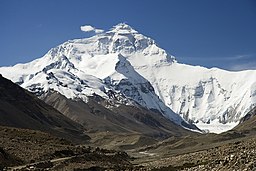
| Everest | Sagarmatha (Nepali), "Head of the World",[14] Chomolungma (Tibetan), "Goddess mother of the snows"[15] | 8,848 | 29,035.44 | 1 | 1953 | East of Kathmandu on Nepal-People's Republic of China (Tibet) border. |
| K2 | Chogo Gangri, Qogir Feng, Mount Godwin Austen, Dapsang | 8,611 | 28,251 | 2 | 1954 | On border between Xinjiang, PRC andPakistan-administered Kashmir. |
| Kangchenjunga | Kangchen Dzö-nga, "Five Treasures of the Great Snow" | 8,586 | 28,169 | 3 | 1955 | On Nepal's far eastern border with Sikkim,India. |
| Lhotse | "South Peak" | 8,516 | 27,940 | 4 | 1956 | On Nepal-PRC (Tibet) border. Part of Everest massif. |
| Makalu | "The Great Black" | 8,462 | 27,765 | 5 | 1955 | On Nepal-PRC (Tibet) border, east of Mt. Everest. |
| Cho Oyu | Qowowuyag, "Turquoise Goddess" | 8,201 | 26,905 | 6 | 1954 | On Nepal-PRC (Tibet) border, west of Mt. Everest. |
| Dhaulagiri | "White Mountain" | 8,167 | 26,764 | 7 | 1960 | Central Nepal, west of Kaligandaki River. |
| Manaslu | Kutang, "Mountain of the Spirit" | 8,156 | 26,758 | 8 | 1956 | Central Nepal, east of Pokhara. |
| Nanga Parbat | Diamir, "Naked Mountain" | 8,126 | 26,660 | 9 | 1953 | Northern Areas of Pakistan. East end of Himalaya, overlooking Indus River. |
| Annapurna | "Goddess of the Harvests" | 8,091 | 26,545 | 10 | 1950 | Central Nepal, north of Pokhara. |
| Gasherbrum I | "Beautiful Mountain" | 8,080 | 26,509 | 11 | 1958 | Pakistan Karakoram |
| Broad Peak | Faichan Kangri | 8,047 | 26,401 | 12 | 1957 | Pakistan Karakoram |
| Gasherbrum II | – | 8,035 | 26,362 | 13 | 1956 | Pakistan Karakoram |
| Shishapangma | Xixiabangma, "Crest Above The Grassy Plains", Gosainthan | 8,013 | 26,289 | 14 | 1964 | Tibet, PRC, about 10 km north of Nepal border. |
| Gyachung Kang | unknown | 7,952 | 26,089 | 15 | 1964 | On Nepal-PRC (Tibet) border. Highest mountain under 8,000 meters. |
| Gasherbrum IV | – | 7,925 | 26,001 | 17 | 1958 | Pakistan Karakoram |
| Masherbrum | unknown | 7,821 | 25,660 | 22 | 1960 | Pakistan Karakoram |
| Nanda Devi | "Bliss-giving Goddess" | 7,817 | 25,645 | 23 | 1936 | Uttarakhand, India. Highest peak entirely within India. |
| Rakaposhi | "Shining Wall" | 7,788 | 25,551 | 1958 | Pakistan Karakoram | |
| Tirich Mir | "King of Shadows" or "King of Tirich Valley" | 7,708 | 25,289 | 1950 | Pakistan near Chitral. Highest peak in Hindu Kush | |
| Gangkhar Puensum | Gankar Punzum, "Three Mountain Siblings" | 7,570 | 24,836 | Unclimbed | Bhutan. World's highest unclimbed peak. Off-limits to mountaineers. | |
| Ismoil Somoni Peak | "Stalin Peak" 1933–1962 "Communism Peak" 1962–1998 | 7,495 | 24,590 | 50 | 1933 | Tajikistan Pamir, highest in former USSR |
| Machapuchare | "Fish Tail" | 6,993 | 22,943 | 1957 (short of actual summit.) | In Annapurna range, appearing Matterhorn-like from Pokhara, Nepal. Considered sacred to Lord Shiva, currently off-limits. | |
| Ama Dablam | "Mother And Her Necklace" | 6,848 | 22,467 | 1961 | Considered by some[who?] to be one of the most beautiful peaks in the Himalayas. InKhumbu region, Nepal. | |
| Kailash | Sanskrit: Kailāsa Parvata, Tibetan:Kang Rinpoche (Precious Snow Peak), Mandarin Chinese:Gāngrénbōqí fēng | 6,638 | 21,778 | Unclimbed | Located in western Tibet near sources ofIndus, Brahmaputra, Karnali and Sutlej Rivers. Sacred to Bön, Buddhist, Hindu andJain religions. Circumambulated by manypilgrims. |
Panorama


Notable Himalayan mountaineers
- George Mallory (1886–1924) Attempted first ascent of Mount Everest in 1922 and 1924; died on North Face along with Sandy Irvine.
- Noel Odell (1890–1987) British. First ascent, in 1936, of Nanda Devi, which remained the highest summitted peak until 1950. Last person to see Mallory and Irvine high up on Everest in 1924.
- Bill Tilman (1898–1977) British. First ascent of Nanda Devi in 1936. In 1934, first person to penetrate Nanda Devi sanctuary
- Frank Smythe (1900–1949) British. Kamet, and early attempt on Kangchenjunga.
- Eric Shipton (1907–1977) British. With Bill Tilman, first to penetrate Nanda Devi sanctuary. Discovered route to Everest over Khumbu Glacier.
- W. H. Murray Deputy leader to Shipton in 1951. Author of The Scottish Himalayan Expedition (1951)
- John Hunt (1910–1998) British. Leader of 1953 expedition of Mount Everest.
- Tenzing Norgay (1914–1986) Nepalese Sherpa mountaineer. First man on Everest's summit along with Edmund Hillary.
- Maurice Herzog (b. 1919) First person to summit an Eight-thousander, Annapurna, in 1950. Lost all toes and most fingers due to frostbite. Peak not climbed again until 1970.
- Sir Edmund Hillary (1919–2008) New Zealand mountaineer and explorer, the first man on Everest's summit along with Tenzing Norgay.
- Tom Bourdillon (1924–1956) member of British Everest expeditions 1951, 1952, and 1953, reached 300 feet (90 m) from summit of Everestthree days before Edmund Hillary and Tenzing Norgay finally conquered it.
- Hermann Buhl (1924–1957) First ascent of Nanga Parbat in 1953 (feat accomplished solo and without oxygen). First ascent of Broad Peak. Died in fall on Chogolisa, body never found.
- Willi Unsoeld (1926–1979) United States. First ascent of Everest from West Face and first major traverse of a Himalayan peak, with Tom Hornbein 1963. Daughter Nanda Devi Unsoeld killed during Nanda Devi expedition 1976. Died during avalanche on Mount Rainier, 1979.
- Chris Bonington (b. 1934) First ascent of Annapurna (South Face), 4 ascents of Everest.
- Nawang Gombu (b. 1936) Indian mountaineer. First person to climb Everest twice: 1963 and 1965.
- Reinhold Messner (born 1944) Italian mountaineer. First man to climb all fourteen mountains over 8000 metres (collectively known as theeight-thousanders).
- Jerzy Kukuczka (1948–1989) Polish mountaineer. Ascended all fourteen eight-thousanders faster than anybody else, establishing ten new routes.
- Erhard Loretan Swiss climber. Ascended all 14 8000ers, most establishing new routes and/or in alpine style.
- Nazir Sabir Pakistani mountaineer. First ascent of two eight thousanders (Broad Peak & Gasherbrum II) in a single attempt.
- Swami Sundaranand (b. 1926 India) Climbed 25 mountains with little or no equipment from 1950–1990 to experience open eyed Samādhiusing the ancient techniques of the Himalayan yogis. Noted also for his extensive photography of the Indian Himalayas.[16][17][18]
- Casey Mackins An English mountaineer who climbed Mt Everest by a new route without oxygen from Tibet in 1984 and then again from Nepal in 1990 during his famous Sea to Summit expedition where he became the first person to climb Everest starting from sea level
- José Antonio Delgado Sucre(1965–2006) was the first Venezuelan mountaineer to reach the summit of five eight-thousanders. He was one of the most experienced climbers in Latin America.
- Ed Viesturs (b. June 22, 1959) is the first American, and 12th person overall, to summit all fourteen eight-thousanders, and the sixth climber to do it without bottled oxygen.
- Pemba Dorjie (born c. 1977) a Sherpa who currently holds the world record for the quickest climb to the summit of Mount Everest from camp. On May 21, 2004 Dorjie set that record, with a total time of 8 hours and 10 minutes.
- Apa Sherpa (born c. 1960) On May 11, 2011, successfully summited Mt. Everest for the 21st time, breaking his own record for most successful ascents.
- Krzysztof Wielicki (born 1950) Polish mountaineer, the fifth man to climb all fourteen eight-thousanders. Three of them (Mount Everest, Kangchenjunga and Lhotse) he ascended as the first man ever to do it in winter.
Religion


Several places in the Himalaya are of religious significance in Hinduism, Jainism, andBuddhism. In Hinduism, the Himalaya have also been personified as the god Himavat, the father of Shiva's consort, Parvati.
Some of the important religious places in the Himalayas are:-
- Haridwar, the place where the river Ganges enters the plains.
- Badrinath, a temple dedicated to Vishnu.
- Kedarnath, where one of the 12 Jyotirlingas is located.
- Gaumukh, the source of the Bhagirathi (and hence, by extension, the Ganges), located a few miles above the town of Gangotri.
- Devprayag, where the Alaknanda and Bhagirathi merge to form the Ganges.
- Rishikesh, has a temple of Lakshmana.
- Mount Kailash, a 6,638 m high peak which is the abode of the Hindu Gods Shiva and Uma and is also venerated by Buddhists. The peak is forbidden to climb, it is so sacred it is circled at its base. Lake Manasarowar lies at the base of Mount Kailash, and is the source of the Brahmaputra.
- Amarnath, has a natural Shiva linga of ice which forms for a few weeks each year. Thousands of people visit this cave during these few weeks.
- The Vaishno Devi is a popular shrine among Durga devotees.
- Sri Hemkund Sahib – Sikh gurudwara where Guru Gobind Singh is claimed to have meditated and achieved enlightenment in a previous incarnation.
In addition to the above, a number of Tibetan Buddhist sites are situated in the Himalaya, including the residence of the Dalai Lama. There were over 6,000 monasteries in Tibet.[19]The Tibetan Muslims had their own mosques in Lhasa and Shigatse.[20]
The following mystic entities are associated with the Himalayas:
- The Yeti is one of the most famous creatures in cryptozoology. It is a large primate-like creature that is supposed to live in the Himalaya. Most mainstream scientists and experts consider current evidence of the Yeti's existence unpersuasive, and the result of hoaxes, legend or misidentification of mundane creatures.
- Shambhala is a mystical city with various legends associated with it, it is one of twenty-four Himalayan hidden realms, or beyul, inVajrayana Buddhism.[21] While some legends consider it to be a real city where secret Buddhist doctrines are being preserved, other legends believe that the city does not physically exist, and can only be reached in the mental realm.

The Himalayas in art, literature, and film
- Kim, by Rudyard Kipling, is the signature account of life in 19th century Indiaas seen through British eyes and is based on the exploits of a young boy in the Himalayas and plains of India while engaged in the Great Game.
- Shangri-La is a fictional utopia situated somewhere in the Himalayas, based on the legendary Shambhala. It is described in the novel Lost Horizon, written by the British writer James Hilton in 1933.
- Tintin in Tibet is one of the series of classic comic-strip albums, written and illustrated by Belgian writer and illustrator Hergé, featuring the young reporter Tintin investigating a plane crash in the Gosain Than massif in the Himalayas. (1960)
- The Hollywood movie Vertical Limit (2000), is set in the K2 peak of the Himalayas, in Pakistan.
- Several levels of Tomb Raider II and one level in Tomb Raider: Legend of the Tomb Raider series are situated in the Himalayas.
- The Inheritance of Loss written by Kiran Desai is partly set in the Himalaya Mountains.
- Rumer Godden's novel Black Narcissus (1939) is about an order of nuns who set up a convent in the Himalayas. The film, released in 1947 by Powell and Pressburger and starring Deborah Kerr, was not actually shot in the Himalayas and relied primarily on matte paintingsto evoke the mountains.
- Isabel Allende's novel, Kingdom of the Golden Dragon takes place mostly in the Forbidden Kingdom, a fictional country in the Himalayas.
- Dragon Rider is authored by Cornelia Funke and tells the story of an epic journey that a small boy, a brownie, and a dragon take to the "Rim of Heaven," a place in the Himalayas where dragons reside.
- Expedition Everest – Legend of the Forbidden Mountain is an elaborately themed roller coaster located at Disney's Animal Kingdom atWalt Disney World that takes riders through a yeti-guarded Mount Everest.
- Seven Years in Tibet is an autobiographical travel book written by Austrian mountaineer Heinrich Harrer based on his real life experiences in Tibet between 1944 and 1951 during the Second World War and the interim period before the PRC's People's Liberation Army invaded Tibet in 1950. Heinrich Harrer took part in a German mountaineering expedition to the Himalayas, intending to climb Nanga Parbat, the ninth-highest mountain in the world.
- Seven Years in Tibet (1997 film) is a 1997 film based on the book of the same name written by Austrian mountaineer Heinrich Harrer.
- Journey of a Red Fridge (2007), directed by Lucian and Natasa Muntean (Lunam Docs), is an award-winning documentary that tells the story of child porters working in the Himalayan mountains of Nepal.
- G.I. Joe: The Movie is a 1987 animated feature, in which an ancient civilization known as Cobra-La has taken refuge deep within the Himalayas after the Ice Age, which nearly wiped them off the face of the Earth.
Tidak ada komentar:
Posting Komentar