 Bagerhat District (Bengali: বাগেরহাট জেলা) is a district in South-westernBangladesh. It is a part of the Khulna Division.
Geography
Bagerhat district has a total area of 3959.11 square kilometres. It is bounded by Gopalganj District and Narail District on the north, The Bay of Bengal on the south, Gopalganj District, Pirojpur District and Barguna District on the east and Khulna District on the west. Main rivers of the district are Panguchi, Daratana, Madhumati River, Pasur River, Haringhata, Mongla River, Baleswar, Bangra and Goshairkhali.
History
Now it is the 4th largest city in Bangladesh
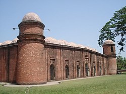
Khan Jahan Ali was the founder of many of the settlements in the district, he settled here in 1429, accompanied by many soldiers under his command. Khan Jahan Ali was the founder of the Khalifabad Pargana which included the areas Bagerhat, Khulna, Satkhira, Jessore and Barisal.[1] Ali was the ruler of the Pargana from 1429 till his death in 1459. Following his death, the region came under the rule of Maharaja Pratapaditya.
During Bangladesh Liberation War of 1971, the Pakistan Army entered the area on 21 April, according to Banglapedia the Army killed about 200 people at Khalishakhali and Babuganj. There were also many mass killings in Doyapara, Shakharikarihat, and at Chakulia of Mollahat. Along with that, 35 people died in a battle in Morelganj between the pro-independence Mukti Bahini and pro-Pakistani Razakar militia.[1]
Economy
One of the two ports of Bangaldesh,Mangla, is here. Rampal and Fakirhat, two upazilla of Bagerhat is known as Qwait of Bangladesh due to its huge production of shrimp and earning a lot of foreign exchange.(55%)
Tidak ada komentar:
Posting Komentar