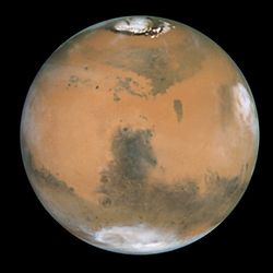
 Mars
Mars is the fourth
planet from the
Sun in the
Solar System. Named after the
Roman god of war, it is often described as the "Red Planet", as the
iron oxide prevalent on its surface gives it a
reddish appearance.
[14] Mars is a
terrestrial planet with a thin
atmosphere, having surface features reminiscent both of the
impact craters of the
Moon and the volcanoes, valleys, deserts, and
polar ice caps of
Earth. The
rotational period
and seasonal cycles of Mars are likewise similar to those of Earth, as
is the tilt that produces the seasons. Mars is the site of
Olympus Mons, the highest known mountain within the Solar System, and of
Valles Marineris, one of the largest canyons. The smooth
Borealis basin in the northern hemisphere covers 40% of the planet and may be a giant impact feature.
[15][16] Mars has two
moons,
Phobos and
Deimos, which are small and irregularly shaped. These may be captured
asteroids, similar to
5261 Eureka, a
Martian trojan asteroid.
Until the first successful flyby of Mars occurred in 1965 by
Mariner 4,
many speculated about the presence of liquid water on the planet's
surface. This was based on observed periodic variations in light and
dark patches, particularly in the polar
latitudes, which appeared to be seas and continents; long, dark
striations were interpreted by some as irrigation channels for liquid water. These straight line features were later explained as
optical illusions, though geological evidence gathered by unmanned missions suggest that Mars once had large-scale water coverage on its surface.
[17] In 2005, radar data revealed the presence of large quantities of water ice at the poles
[18] and at mid-latitudes.
[19][20] The Mars rover
Spirit sampled chemical compounds containing water molecules in March 2007. The
Phoenix lander directly sampled water ice in shallow Martian soil on July 31, 2008.
[21]
Mars is currently host to five functioning
spacecraft: three in orbit—the
Mars Odyssey,
Mars Express, and
Mars Reconnaissance Orbiter; and two on the surface—
Mars Exploration Rover Opportunity and the
Mars Science Laboratory Curiosity. Defunct spacecraft on the surface include MER-A
Spirit, and several other inert landers and rovers, both successful and unsuccessful, such as the
Phoenix lander, which completed its mission in 2008. Observations by
NASA's now-defunct
Mars Global Surveyor show evidence that parts of the southern polar ice cap have been receding.
[22] Observations by the
Mars Reconnaissance Orbiter have revealed possible flowing water during the warmest months on Mars.
[23]
Mars can easily be seen from Earth with the naked eye. Its
apparent magnitude reaches −3.0,
[7] which is only surpassed by
Jupiter,
Venus,
the Moon, and the Sun. Optical ground-based telescopes are typically
limited to resolving features about 300 km (186 miles) across when Earth
and Mars are closest, because of Earth's atmosphere.
Physical characteristics
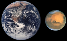
Size comparison of
Earth and Mars.
Mars has approximately half the
diameter of Earth. It is less dense than Earth, having about 15% of Earth's volume and 11% of the
mass. Its
surface area is only slightly less than the total area of Earth's dry land.
[6] While Mars is larger and more massive than
Mercury,
Mercury has a higher density. This results in the two planets having a
nearly identical gravitational pull at the surface—that of Mars is
stronger by less than 1%. The red-orange appearance of the Martian
surface is caused by
iron(III) oxide, more commonly known as
hematite, or rust.
[25] It can also look butterscotch,
[26] and other common surface colors include golden, brown, tan, and greenish, depending on minerals.
[26]
Internal structure
Like Earth, this planet has undergone
differentiation, resulting in a dense, metallic core region overlaid by less dense materials.
[27] Current models of the planet's interior imply a core region about
1794 ± 65 km in radius, consisting primarily of
iron and
nickel with about 16–17%
sulfur.
[28] This
iron sulfide
core is partially fluid, and has twice the concentration of the lighter
elements that exist at Earth's core. The core is surrounded by a
silicate
mantle
that formed many of the tectonic and volcanic features on the planet,
but now appears to be dormant. Besides silicon and oxygen, the most
abundant elements in the martian crust are iron, magnesium, aluminum,
calcium, and potassium. The average thickness of the planet's crust is
about 50 km, with a maximum thickness of 125 km.
[29] Earth's crust, averaging 40 km, is only one third as thick as Mars's crust, relative to the sizes of the two planets. The
InSight lander planned for 2016 will use a
seismometer to better constrain the models of the interior.
Surface geology
Mars is a
terrestrial planet that consists of minerals containing
silicon and
oxygen,
metals, and other elements that typically make up
rock. The surface of Mars is primarily composed of
tholeiitic basalt,
[30] although parts are more
silica-rich than typical basalt and may be similar to
andesitic rocks on Earth or silica glass. Regions of low
albedo show concentrations of
plagioclase feldspar,
with northern low albedo regions displaying higher than normal
concentrations of sheet silicates and high-silicon glass. Parts of the
southern highlands include detectable amounts of high-calcium
pyroxenes. Localized concentrations of
hematite and
olivine have also been found.
[31] Much of the surface is deeply covered by finely grained
iron(III) oxide dust.
[32][33]
Although Mars has no evidence of a current structured global
magnetic field,
[34]
observations show that parts of the planet's crust have been
magnetized, and that alternating polarity reversals of its dipole field
have occurred in the past. This
paleomagnetism of magnetically susceptible minerals has properties that are very similar to the
alternating bands found on the ocean floors of Earth. One theory, published in 1999 and re-examined in October 2005 (with the help of the
Mars Global Surveyor), is that these bands demonstrate
plate tectonics on Mars four
billion years ago, before the planetary
dynamo ceased to function and the planet's magnetic field faded away.
[35]
During the
Solar System's formation, Mars was created as the result of a
stochastic process of run-away accretion out of the
protoplanetary disk
that orbited the Sun. Mars has many distinctive chemical features
caused by its position in the Solar System. Elements with comparatively
low boiling points such as chlorine, phosphorus and sulphur are much
more common on Mars than Earth; these elements were probably removed
from areas closer to the Sun by the young star's energetic
solar wind.
[36]
After the formation of the planets, all were subjected to the so-called "
Late Heavy Bombardment". About 60% of the surface of Mars shows a record of impacts from that era,
[37][38][39]
while much of the remaining surface is probably underlain by immense
impact basins caused by those events. There is evidence of an enormous
impact basin in the northern hemisphere of Mars, spanning 10,600 km by
8,500 km, or roughly four times larger than the Moon's
South Pole – Aitken basin, the largest impact basin yet discovered.
[15][16] This theory suggests that Mars was struck by a
Pluto-sized body about four billion years ago. The event, thought to be the cause of the
Martian hemispheric dichotomy, created the smooth
Borealis basin that covers 40% of the planet.
[40][41]
The geological history of Mars can be split into many periods, but the following are the three primary periods:
[42][43]
- Noachian period (named after Noachis Terra):
Formation of the oldest extant surfaces of Mars, 4.5 billion years ago
to 3.5 billion years ago. Noachian age surfaces are scarred by many
large impact craters. The Tharsis
bulge, a volcanic upland, is thought to have formed during this period,
with extensive flooding by liquid water late in the period.
- Hesperian period (named after Hesperia Planum): 3.5 billion years ago to 2.9–3.3 billion years ago. The Hesperian period is marked by the formation of extensive lava plains.
- Amazonian period (named after Amazonis Planitia): 2.9–3.3 billion years ago to present. Amazonian regions have few meteorite impact craters, but are otherwise quite varied. Olympus Mons formed during this period, along with lava flows elsewhere on Mars.
Some geological activity is still taking place on Mars. The
Athabasca Valles is home to sheet-like lava flows up to about 200
Mya. Water flows in the grabens called the
Cerberus Fossae occurred less than 20 Mya, indicating equally recent volcanic intrusions.
[44] On February 19, 2008, images from the
Mars Reconnaissance Orbiter showed evidence of an avalanche from a 700 m high cliff.
[45]
Soil
Main article:
Martian soil
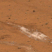
Rover exposes silica-rich dust
The
Phoenix lander returned data showing Martian soil to be slightly alkaline and containing elements such as
magnesium,
sodium,
potassium and
chlorine. These nutrients are found in gardens on Earth, and are necessary for growth of plants.
[46] Experiments performed by the Lander showed that the Martian soil has a
basic pH of 8.3, and may contain traces of the
salt perchlorate.
[48]
Streaks are common across Mars and new ones appear frequently on
steep slopes of craters, troughs, and valleys. The streaks are dark at
first and get lighter with age. Sometimes, the streaks start in a tiny
area which then spread out for hundreds of metres. They have also been
seen to follow the edges of boulders and other obstacles in their path.
The commonly accepted theories include that they are dark underlying
layers of soil revealed after avalanches of bright dust or dust devils.
[49] Several explanations have been put forward, some of which involve
water or even the growth of organisms.
[50][51]
Hydrology
Main article:
Water on Mars
Liquid water cannot exist on the surface of Mars due to low
atmospheric pressure, except at the lowest elevations for short periods.
[52][53] The two polar ice caps appear to be made largely of water.
[54][55]
The volume of water ice in the south polar ice cap, if melted, would be
sufficient to cover the entire planetary surface to a depth of 11
meters.
[56] A
permafrost mantle stretches from the pole to latitudes of about 60°.
[54]
Large quantities of water ice are thought to be trapped within the thick
cryosphere of Mars. Radar data from
Mars Express and the
Mars Reconnaissance Orbiter show large quantities of water ice both at the poles (July 2005)
[18][57] and at mid-latitudes (November 2008).
[19] The Phoenix lander directly sampled water ice in shallow Martian soil on July 31, 2008.
[21]
Landforms
visible on Mars strongly suggest that liquid water has at least at
times existed on the planet's surface. Huge linear swathes of scoured
ground, known as
outflow channels,
cut across the surface in around 25 places. These are thought to record
erosion which occurred during the catastrophic release of water from
subsurface aquifers, though some of these structures have also been
hypothesised to result from the action of glaciers or lava.
[58][59] The youngest of these channels are thought to have formed as recently as only a few million years ago.
[60] Elsewhere, particularly on the oldest areas of the martian surface, finer-scale, dendritic
networks of valleys
are spread across significant proportions of the landscape. Features of
these valleys and their distribution very strongly imply that they were
carved by
runoff resulting from rain or snow fall in early Mars history. Subsurface water flow and
groundwater sapping
may play important subsidiary roles in some networks, but precipitation
was probably the root cause of the incision in almost all cases.
[61]
There are also thousands of features along crater and canyon walls that appear similar to terrestrial
gullies.
The gullies tend to be in the highlands of the southern hemisphere and
to face the Equator; all are poleward of 30° latitude. A number of
authors have suggested that their formation process demands the
involvement of liquid water, probably from melting ice,
[62][63] although others have argued for formation mechanisms involving carbon dioxide frost or the movement of dry dust.
[64][65]
No partially degraded gullies have formed by weathering and no
superimposed impact craters have been observed, indicating that these
are very young features, possibly even active today.
[63]
Other geological features, such as
deltas and
alluvial fans
preserved in craters, also argue very strongly for warmer, wetter
conditions at some interval or intervals in earlier Mars history.
[66] Such conditions necessarily require the widespread presence of crater
lakes
across a large proportion of the surface, for which there is also
independent mineralogical, sedimentological and geomorphological
evidence.
[67]
Some authors have even gone so far as to argue that at times in the
martian past, much of the low northern plains of the planet were covered
with a true ocean hundreds of meters deep, though this remains
controversial.
[68]
Further evidence that
liquid water once existed on the surface of Mars comes from the detection of specific minerals such as
hematite and
goethite, both of which sometimes form in the presence of water.
[69]
Some of the evidence believed to indicate ancient water basins and
flows has been negated by higher resolution studies by the Mars
Reconnaissance Orbiter.
[70] In 2004,
Opportunity detected the mineral
jarosite. This forms only in the presence of acidic water, which demonstrates that water once existed on Mars.
[71]
More recent evidence for liquid water comes from the finding of the
mineral gypsum on the surface by NASA's Mars rover Opportunity in
December 2011.
[72][73]
Additionally, the study leader Francis McCubbin, a planetary scientist
at the University of New Mexico in Albuquerque looking at hydroxals in
crystalline minerals from Mars states the amount of water in the upper
mantle of Mars is equal to or greater than that of Earth at 50–300 parts
per million of water, which is enough to cover the entire planet to a
depth of 200 to 1000 meters.
[74]
Polar caps
Northern ice cap of Mars in 1999
Mars has two permanent polar ice caps. During a pole's winter, it
lies in continuous darkness, chilling the surface and causing the
deposition of 25–30% of the atmosphere into slabs of
CO2 ice (
dry ice).
[75] When the poles are again exposed to sunlight, the frozen CO
2 sublimes,
creating enormous winds that sweep off the poles as fast as 400 km/h.
These seasonal actions transport large amounts of dust and water vapor,
giving rise to Earth-like frost and large
cirrus clouds. Clouds of water-ice were photographed by the
Opportunity rover in 2004.
[76]
The polar caps at both poles consist primarily of water ice. Frozen
carbon dioxide accumulates as a comparatively thin layer about one metre
thick on the north cap in the northern winter only, while the south cap
has a permanent dry ice cover about eight metres thick.
[77] The northern polar cap has a diameter of about 1,000 kilometres during the northern Mars summer,
[78] and contains about 1.6 million cubic km of ice, which, if spread evenly on the cap, would be 2 km thick.
[79] (This compares to a volume of 2.85 million cubic km (km
3) for the
Greenland ice sheet.) The southern polar cap has a diameter of 350 km and a thickness of 3 km.
[80]
The total volume of ice in the south polar cap plus the adjacent
layered deposits has also been estimated at 1.6 million cubic km.
[81] Both polar caps show spiral troughs, which recent analysis of
SHARAD ice penetrating radar has shown are a result of
katabatic winds that spiral due to the
Coriolis Effect.
[82][83]
The seasonal frosting of some areas near the southern ice cap results
in the formation of transparent 1 metre thick slabs of dry ice above
the ground. With the arrival of spring, sunlight warms the subsurface
and pressure from subliming CO
2 builds up under a slab, elevating and ultimately rupturing it. This leads to
geyser-like eruptions of CO
2
gas mixed with dark basaltic sand or dust. This process is rapid,
observed happening in the space of a few days, weeks or months, a rate
of change rather unusual in geology—especially for Mars. The gas rushing
underneath a slab to the site of a geyser carves a spider-like pattern
of radial channels under the ice.
[84][85][86][87]
Geography

Volcanic plateaus (red) and impact basins (blue) dominate this topographic map of Mars
Although better remembered for mapping the Moon,
Johann Heinrich Mädler and
Wilhelm Beer
were the first "areographers". They began by establishing that most of
Mars's surface features were permanent, and more precisely determining
the planet's rotation period. In 1840, Mädler combined ten years of
observations and drew the first map of Mars. Rather than giving names to
the various markings, Beer and Mädler simply designated them with
letters; Meridian Bay (Sinus Meridiani) was thus feature "
a".
[88]
Today, features on Mars are named from a variety of sources. Albedo
features are named for classical mythology. Craters larger than 60
kilometres (37 mi) are named for deceased scientists and writers and
others who have contributed to the study of Mars. Craters smaller than
60 km are named for towns and villages of the world with populations of
less than 100,000. Large valleys are named for the word mars or star in
various languages, small valleys are named for rivers.
[89]
Large
albedo
features retain many of the older names, but are often updated to
reflect new knowledge of the nature of the features. For example,
Nix Olympica (the snows of Olympus) has become
Olympus Mons (Mount Olympus).
[90]
The surface of Mars as seen from Earth is divided into two kinds of
areas, with differing albedo. The paler plains covered with dust and
sand rich in reddish iron oxides were once thought of as Martian
"continents" and given names like
Arabia Terra (
land of Arabia) or
Amazonis Planitia (
Amazonian plain). The dark features were thought to be seas, hence their names
Mare Erythraeum, Mare Sirenum and
Aurorae Sinus. The largest dark feature seen from Earth is
Syrtis Major Planum.
[91] The permanent northern polar ice cap is named
Planum Boreum, while the southern cap is called
Planum Australe.
Mars's equator is defined by its rotation, but the location of its
Prime Meridian was specified, as was Earth's (at
Greenwich), by choice of an arbitrary point; Mädler and Beer selected a line in 1830 for their first maps of Mars. After the spacecraft
Mariner 9 provided extensive imagery of Mars in 1972, a small crater (later called
Airy-0), located in the
Sinus Meridiani ("Middle Bay" or "Meridian Bay"), was chosen for the definition of 0.0° longitude to coincide with the original selection.
[92]
Since Mars has no oceans and hence no "sea level", a zero-elevation
surface also had to be selected as a reference level; this is also
called the
areoid[93] of Mars, analogous to the terrestrial
geoid. Zero altitude was defined by the height at which there is 610.5
Pa (6.105
mbar) of atmospheric pressure.
[94] This pressure corresponds to the
triple point of water, and is about 0.6% of the sea level surface pressure on Earth (0.006 atm).
[95] In practice, today this surface is defined directly from satellite gravity measurements.
Impact topography

Panorama of
Gusev crater, where
Spirit rover examined volcanic basalts
The dichotomy of Martian topography is striking: northern plains
flattened by lava flows contrast with the southern highlands, pitted and
cratered by ancient impacts. Research in 2008 has presented evidence
regarding a theory proposed in 1980 postulating that, four billion years
ago, the northern hemisphere of Mars was struck by an object one-tenth
to two-thirds the size of
the Moon.
If validated, this would make the northern hemisphere of Mars the site
of an impact crater 10,600 km long by 8,500 km wide, or roughly the area
of Europe, Asia, and Australia combined, surpassing the
South Pole – Aitken basin as the largest impact crater in the Solar System.
[15][16]
Mars is scarred by a number of
impact craters: a total of 43,000 craters with a diameter of 5 km or greater have been found.
[96] The largest confirmed of these is the
Hellas impact basin, a light
albedo feature clearly visible from Earth.
[97]
Due to the smaller mass of Mars, the probability of an object colliding
with the planet is about half that of the Earth. Mars is located closer
to the asteroid belt, so it has an increased chance of being struck by
materials from that source. Mars is also more likely to be struck by
short-period
comets, i.e. those that lie within the orbit of Jupiter.
[98]
In spite of this, there are far fewer craters on Mars compared with the
Moon, because the atmosphere of Mars provides protection against small
meteors. Some craters have a morphology that suggests the ground became
wet after the meteor impacted.
[99]
Volcanoes
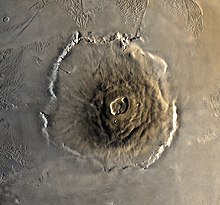
Top down view of
Olympus Mons, the highest known mountain in the solar system
The
shield volcano,
Olympus Mons (
Mount Olympus), at 27 km is the highest known mountain in the Solar System.
[100] It is an extinct volcano in the vast upland region
Tharsis, which contains several other large volcanoes. Olympus Mons is over three times the height of
Mount Everest, which in comparison stands at just over 8.8 km.
[101]
Tectonic sites
The large canyon,
Valles Marineris (Latin for
Mariner Valleys,
also known as Agathadaemon in the old canal maps), has a length of
4,000 km and a depth of up to 7 km. The length of Valles Marineris is
equivalent to the length of Europe and extends across one-fifth the
circumference of Mars. By comparison, the
Grand Canyon
on Earth is only 446 km long and nearly 2 km deep. Valles Marineris was
formed due to the swelling of the Tharsis area which caused the crust
in the area of Valles Marineris to collapse. Another large canyon is
Ma'adim Vallis (
Ma'adim is
Hebrew
for Mars). It is 700 km long and again much bigger than the Grand
Canyon with a width of 20 km and a depth of 2 km in some places. It is
possible that Ma'adim Vallis was flooded with liquid water in the past.
[102] In 2012, plate tectonics are reported to occur on Mars.
[103]
Caves

THEMIS
image of probable Mars cave entrances, informally named (A) Dena, (B)
Chloe, (C) Wendy, (D) Annie, (E) Abby (left) and Nikki, and (F) Jeanne.
Images from the
Thermal Emission Imaging System (THEMIS) aboard NASA's
Mars Odyssey orbiter have revealed seven possible
cave entrances on the flanks of the
Arsia Mons volcano.
[104] The caves, named after loved ones of their discoverers, are collectively known as the "seven sisters."
[105]
Cave entrances measure from 100 m to 252 m wide and they are believed
to be at least 73 m to 96 m deep. Because light does not reach the floor
of most of the caves, it is likely that they extend much deeper than
these lower estimates and widen below the surface. "Dena" is the only
exception; its floor is visible and was measured to be 130 m deep. The
interiors of these caverns may be protected from micrometeoroids, UV
radiation,
solar flares and high energy particles that bombard the planet's surface.
[106]
Atmosphere
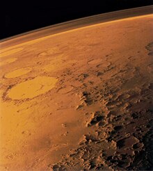
The tenuous atmosphere of Mars, visible on the horizon in this low-orbit photo
Mars lost its
magnetosphere 4 billion years ago,
[107] so the
solar wind interacts directly with the Martian
ionosphere, lowering the atmospheric density by stripping away atoms from the outer layer. Both
Mars Global Surveyor and Mars Express have detected ionised atmospheric particles trailing off into space behind Mars,
[107][108] and this atmospheric loss will be studied by the upcoming
MAVEN orbiter. Compared to Earth, the
atmosphere of Mars is quite rarefied.
Atmospheric pressure on the surface today ranges from a low of 30
Pa (0.030
kPa) on
Olympus Mons to over 1,155 Pa (1.155 kPa) in the
Hellas Planitia, with a mean pressure at the surface level of 600 Pa (0.60 kPa).
[109] The highest atmospheric density on Mars is equal to the density found 35 km
[110] above the Earth's surface. The resulting maximum surface pressure is only 0.6% of that of the Earth (101.3 kPa). The
scale height of the atmosphere is about 10.8 km,
[111]
which is higher than Earth's (6 km) because the surface gravity of Mars
is only about 38% of Earth's, an effect offset by both the lower
temperature and 50% higher average molecular weight of the atmosphere of
Mars.
The atmosphere of Mars consists of about 95%
carbon dioxide, 3%
nitrogen, 1.6%
argon and contains traces of
oxygen and water.
[6] The atmosphere is quite dusty, containing particulates about 1.5
µm in diameter which give the Martian sky a
tawny color when seen from the surface.
[112]
Methane has been detected in the Martian atmosphere with a
mole fraction of about 30
ppb;
[12][113]
it occurs in extended plumes, and the profiles imply that the methane
was released from discrete regions. In northern midsummer, the principal
plume contained 19,000 metric tons of methane, with an estimated source
strength of 0.6 kilogram per second.
[114][115]
The profiles suggest that there may be two local source regions, the
first centered near 30° N, 260° W and the second near 0°, 310° W.
[114] It is estimated that Mars must produce 270 ton/year of methane.
[114][116]
The implied methane destruction lifetime may be as long as about 4 Earth years and as short as about 0.6 Earth years.
[114][117] This rapid turnover would indicate an active source of the gas on the planet.
Volcanic activity,
cometary impacts, and the presence of
methanogenic microbial life forms are among possible sources. Methane could also be produced by a non-biological process called
serpentinization[b] involving water, carbon dioxide, and the
mineral olivine, which is known to be common on Mars.
[118]
Ammonia was also tentatively detected on Mars by the Mars Express
satellite, but with its relatively short lifetime, it is not clear what
produced it.
[119] Ammonia is not stable there and breaks down after a few hours, so one possible source is volcanic activity.
[119]
Climate
Of all the planets in the Solar System, the seasons of Mars are the
most Earth-like, due to the similar tilts of the two planets' rotational
axes. The lengths of the Martian seasons are about twice those of
Earth's, as Mars's greater distance from the Sun leads to the Martian
year being about two Earth years long. Martian surface temperatures vary
from lows of about
−143 °C (−225 °F) (at the winter polar caps)
[8] to highs of up to
35 °C (95 °F) (in equatorial summer).
[9]
The wide range in temperatures is due to the thin atmosphere which
cannot store much solar heat, the low atmospheric pressure, and the low
thermal inertia of Martian soil.
[120] The planet is also 1.52 times as far from the sun as Earth, resulting in just 43% of the amount of sunlight.
[121]
If Mars had an Earth-like orbit, its seasons would be similar to Earth's because its
axial tilt is similar to Earth's. The comparatively large eccentricity of the Martian orbit has a significant effect. Mars is near
perihelion when it is summer in the southern hemisphere and winter in the north, and near
aphelion
when it is winter in the southern hemisphere and summer in the north.
As a result, the seasons in the southern hemisphere are more extreme and
the seasons in the northern are milder than would otherwise be the
case. The summer temperatures in the south can reach up to
30 °C (54.0 °F) warmer than the equivalent summer temperatures in the north.
[122]
Mars also has the largest
dust storms
in our Solar System. These can vary from a storm over a small area, to
gigantic storms that cover the entire planet. They tend to occur when
Mars is closest to the Sun, and have been shown to increase the global
temperature.
[123]
Orbit and rotation
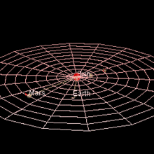
Mars's average distance from the Sun is roughly 230 million km (1.5 AU,
or 143 million miles) and its orbital period is 687 (Earth) days as
depicted by the red trail, with Earth's orbit shown in blue.(Animation)
Mars's average distance from the Sun is roughly 230 million km (1.5
AU) and its orbital period is 687 (Earth) days. The solar day (or
sol)
on Mars is only slightly longer than an Earth day: 24 hours, 39
minutes, and 35.244 seconds. A Martian year is equal to 1.8809 Earth
years, or 1 year, 320 days, and 18.2 hours.
[6]
The axial tilt of Mars is 25.19 degrees, which is similar to the axial tilt of the Earth.
[6]
As a result, Mars has seasons like the Earth, though on Mars, they are
nearly twice as long given its longer year. Currently, the orientation
of the
north pole of Mars is close to the star
Deneb.
[13] Mars passed an
aphelion in March 2010
[124] and its
perihelion in March 2011.
[125] The next aphelion came in February 2012
[125] and the next perihelion comes in January 2013.
[125]
Mars has a relatively pronounced
orbital eccentricity of about 0.09; of the seven other planets in the Solar System, only
Mercury
shows greater eccentricity. It is known that in the past, Mars has had a
much more circular orbit than it does currently. At one point, 1.35
million Earth years ago, Mars had an eccentricity of roughly 0.002, much
less than that of Earth today.
[126] The Mars cycle of eccentricity is 96,000 Earth years compared to the Earth's cycle of 100,000 years.
[127]
Mars also has a much longer cycle of eccentricity with a period of 2.2
million Earth years, and this overshadows the 96,000-year cycle in the
eccentricity graphs. For the last 35,000 years, the orbit of Mars has
been getting slightly more eccentric because of the gravitational
effects of the other planets. The closest distance between the Earth and
Mars will continue to mildly decrease for the next 25,000 years.
[128]
Images comparing Mars's orbit with
Ceres, a
dwarf planet in the
asteroid belt. The left is shown from the north
ecliptic
pole. The right is shown from the ascending node. The segments of
orbits south of the ecliptic are plotted in darker colors. The
perihelia (q) and
aphelia (Q) are labelled with the date of nearest passage. The orbit of Mars is red, Ceres is yellow.